…one bite at a time. Or as in our case, one mile at a time.
In this post I want to bring everyone up to speed on what is happening with construction of the Birthplace of America Trail, or as some call it, BoAT. In trying to build a 95 mile long trail, there are a lot of moving parts that happen at the same time. Some things happen faster than others and that is reasonable when you have a 95 mile long project. Sometimes what is happening over in Surry County is different than what is happening in the community of Phoebus over in Hampton. All things have to be coordinated to ensure, that as we proceed in getting this trail built, it all happens according to the plan.
The Tidewater Trails Alliance (TTA) is made up of a volunteer board of directors. Our board members all have different talents and skill sets that work together in a forward moving effort to get this trail built. We use the guide or plan that was set forth in the HRTPO report for the Birthplace of America Trail. This plan was approved in July of 2017 and the reason the TTA was formed last year.
Anyone that is interested in the plan, I encourage you to go to the HRTPO website and download the PDF “Final Document” at the bottom of this page for BoAT
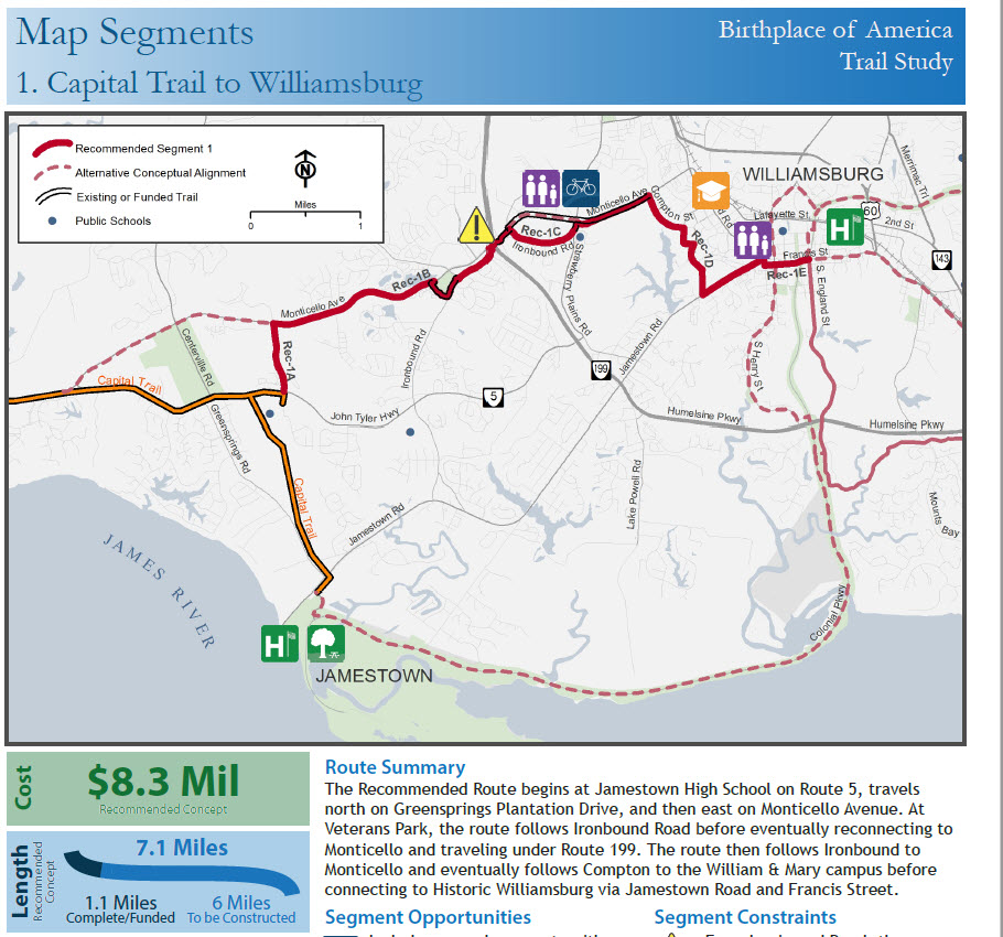
Starting at about page 27, you start seeing the trail alignment layout of the different Segments of the trail. Segment 1 is what we will talk about here in a second and is the picture on this post. In all, there are 10 Segments that total roughly 95 miles. At an estimated cost of 1.4 million dollars per mile, you can see how this conservatively adds up to about $133 million dollars to build this project to completion.
But with time, we will have inflation that affects that end dollar amount. And with time and changing transportation needs, this trail will shrink and expand several times. There are already some “choke” points that are getting attention of the TTA Design & Construction Committee team. These choke points may alter the layout of some sections that we can discuss at another time.
Just know that there are three Segments that we are watching now and warrant our attention. These are Segments 1, 6 and 7. Go head, look them up in the BoAT Plan provided by HRTPO…, time to get familiar with the plan so you will be on the same page as the TTA.
Segment 7 deals with the section between the Jamestown-Surry Ferry Landing at Scotland and running along Rolfe Highway into the town of Surry. Presently, there is a VDOT Smartscale application that was submitted by the county to widen Rolfe Highway between the ferry and Town of Surry. The Smartscale Application was done under the guise of widening the road to provide “bicycle accommodations” on each side. THIS IS NOT WHAT IS IN THE SURRY COUNTY Approved Bike / Ped. plan, which calls for a separate multi-use path (MUP) alongside Rolfe Highway for bicycle and pedestrian travel.
The TTA has been working diligently with the county officials and the Commonwealth Transportation Board to ensure that the Surry County Bike / Ped Plan, the BoAT plan and East Coast Greenway Plan are adhered to. The TTA understands the need to widen this road to accommodate farm equipment and vehicular safety space, so we are trying to work towards a win-win situation to ensure there is enough real estate left at the end of this road widening project to allow a 10′ wide separated MUP. Also in the mix is an HRSD force main project that may provide a workable solution should HRSD allow a “Utility with Trails” co-alignment. We will keep you updated on this project as it develops.
Segment 6 deals with the downtown Hampton section as it passes Hampton University and goes through Phoebus and into Fort Monroe. No construction efforts are underway in this area (presently) other than the announced expansion of the Hampton Roads Bridge Tunnel (HRBT) and widening of I-64. When construction of this highway starts, there will be one overpass that will be impacted in regard to the BoAT alignment. The current Mallory Street bridge between the VA Medical Center and Phoebus will be reworked due to I-64 widening. This bridge is the last overpass before the approach to the HRBT.
Indication are that a new MUP will be included in the bridge design that is similar to the overpass between the Coliseum and Bass Pro Shops on Pine Chapel Road. This trail project known as the Central Park Water Trail goes between Air Power Park and Bluebird Gap Farm and is nearing completion (yea Hampton). All indications point towards a Mallory Street bridge with a shared use path. This design can be used for the BoAT alignment and this is great news. Thank you City of Hampton and HRTPO for your diligence in this matter.
Segment 1 – We are finally to the section that is showing the first signs of construction planning that is getting ready for execution. This Segment deals with the co-aligning of the Virginia Capital Trail (VCT) and BoAT from Jamestown High School to the entrance of Colonial Williamsburg. The goal in this segment was to get the VCT to the actual Colonial Governors Mansion in Colonial Williamsburg. In addition, since the BoAT study called for extension of this new project from the Jamestown Festival Park to Fort Monroe, our two trail projects have a common goal and alignment.
In the initial planning stages, the engineering group looked at several factors in the proposed trail; Feasibility, Destination of where riders/ pedestrians want to go and Active Transportation needs. The planners also looked at what was on the books as being funded and where certain sections were already on the ground. The map on page 27 of the study shows this alignment going into Colonial Williamsburg.
So the next set of construction that everyone will see is between Ironbound Road and Compton Road in Williamsburg. This will connect the Newtown shopping area of Williamsburg with the College of William & Mary. This section should start construction late 2019 / early 2020. So we are excited to see this on the horizon. Thank you to City of Williamsburg and James City County for being proactive in your endeavor to connect the entire population of this region via cycling and walking paths. No wonder this area is known as a Bicycle Friendly community by the League of American Bicyclist.
As you can see, there is a lot that is going on in this project and we are just at the tip of the trail building effort. But as it goes, we need to eat this elephant one bite at a time…or as in our case, one mile at a time. Thank you for your time in reading this and until later – Tom
Thanks for the thorough update, Tom! This “appetizer” of the whole elephant meal is very exciting!